LiDAR Data
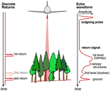
From a satellite or airborne platform, we can also have a sensor send out a pulse signal. The time it takes to return can then be an estimate of the distance to the surface, or the actual height of the surface at that point. This is what we call point cloud data, see the figure for a visual explanation.
 |
The 3D pattern found in these point clouds can be used to classify vegetation. Based on absolute height, density, and the pattern of the points, algorithms can differentiate between different types of vegetation. Point cloud data also provides information on roughness for various types of vegetation, which is needed for water resistance equations and flood modelling (Antonarakis et al. 2008).
For classifying vegetation in the floodplains in The Netherlands we use Light Detection And Ranging (LiDAR) data. The Actueel Hoogtebestand Nederland (AHN) provides LiDAR point cloud data for the whole of The Netherlands. A laser pulse can result in multiple returns and also penetrate through the vegetation, this results in a point cloud with points of the vegetation and points on the ground. The AHN has been extensively tested, and has a high quality (Zon 2011). The mean point density of the AHN varies between 6 and 10 points per m2, depending on the land cover and possible overlap between flights.
The quality and density of the point cloud data depends on different characteristics of the photos, such as quality of the geo-referencing, amount of overlap, contrast, and ground clearance. Shadows and low contrast in vegetated areas may result locally in lower density and accuracy (Poon et al. 2005). The point cloud does not contain points beneath the canopy.
Antonarakis et al. 2008. “Object-Based Land Cover Classification Using Airborne LiDAR.” Remote Sensing of Environment 112 (6). Elsevier: 2988–98.
Poon, Joanne, Clive S Fraser, Zhang Chunsun, Zhang Li, and Armin Gruen. 2005. “Quality Assessment of Digital Surface Models Generated from IKONOS Imagery.” The Photogrammetric Record 20 (110). Wiley Online Library: 162–71.
Zon, Niels van der. 2011. “Kwaliteitsdocument AHN-2.” Rijkswaterstaat & Waterschappen, Tech. Rep 1: 1.