Spectral Imagery
We can take photos from satellite or airborne platforms. These can be spectral images, which display the reflectance of the surface along the electromagnetic spectrum. Often, we do not record the entire spectrum, but just a few snapshots along the spectrum, which we call spectral bands.
The images derived in such a way, from satellites or airborne systems, have a wide range in temporal, spatial, and spectral resolution.The amount of times we take photos indicate the temporal resolution, when we have more photos within a year, we have a higher temporal resolution.The spectral information of the surface is recorded per pixel. A pixel represents an area of the surface, and the size of the area the pixel represents indicates the spatial resolution. When we have a smaller area per pixel, the spatial resolution is higher. The number of spectral bands indicate the spectral resolution; more bands means a higher cover of the entire electromagnetic spectrum, and thus a higher resolution.
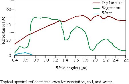
The most common sensors collect data in the visible light regions of the spectrum as well as in the near-infrared (NIR) part of the spectrum. The advantage of spectral imagery is that the reflection, transmittance, and absorption of the recorded objects is different, depending on the band. As many objects, such as vegetation and water have characteristic reflection or absorption features at certain wavelengths, spectral imagery can be used to identify these objects to produce maps (Santosh and Sundaresan 2014). These deterministic features can be referred to as spectral signatures. The image below shows the averaged signatures for water, soil and vegetation (Canadian Remote Sensing Society 2016).
Canadian Remote Sensing Society. 2016. Online Picture. http://www.ucalgary.ca/GEOG/Virtual/Remote%20Sensing/reflectance.gif.
Santosh and Sundaresan. 2014. “Remote Sensing Basics.” In Geospatial Technologies and Climate Change, 279–90. Springer.